


Breaking news


Airbus showcases DeckFinder technology during COMPASS2020.
During the COMPASS2020 demonstration, Airbus showcased their DeckFinder technology to launch and recover a rotary wing UAV from the Portuguese Offshore Patrol Vessel NRP Setubal, successfully completing more than 10 fully autonomous launches and recoveries.
Follow Navy Recognition on Google News at this link
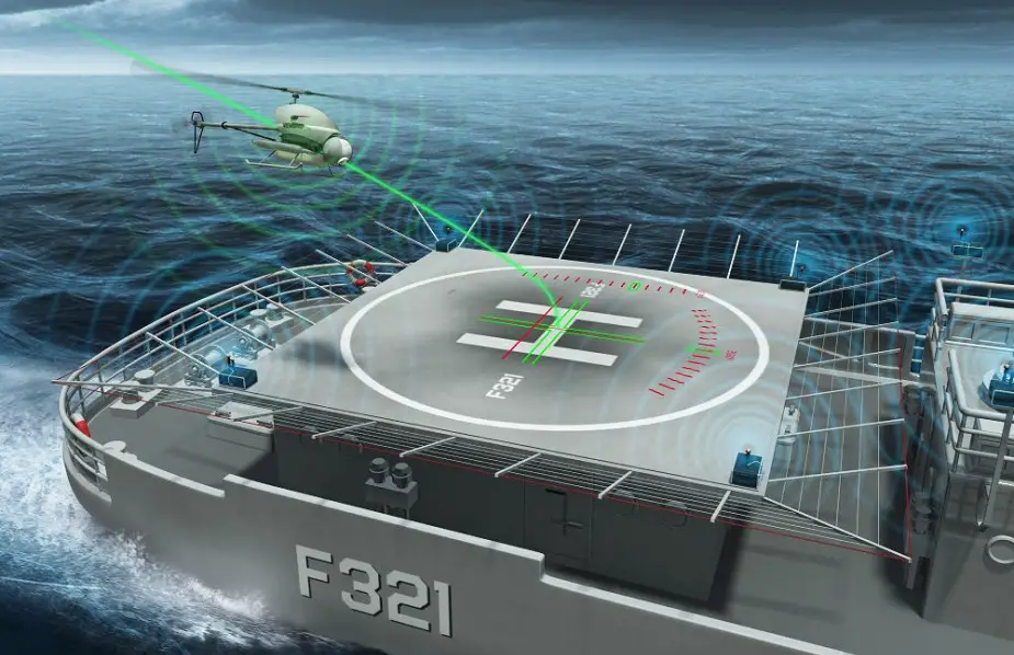 When landing on small or moving helidecks, a difference of a few centimeters can compromise and endanger a whole mission. To avoid such risk, DeckFinder provides a 3-dimensional image of the RPASs relative position, aiding in landing the aerial vehicle safely (Picture source: Airbus)
The safe and successful launch and recovery of rotary wing UAVs play a pivotal role in a nation’s border security capability and DeckFinder demonstrated it can extend the capability of a UAV so it’s available across the broadest operational envelope. Such innovative technologies allow border protection and security agencies to fulfil their missions, such as the narcotics smuggling and anomalous migration missions demonstrated during the COMPASS2020 campaign.
DeckFinder is a local positioning system that lets manned and remotely piloted aerial vehicles (RPAS) determine their relative position in the harshest environmental conditions. The independent navigation system contributes to easier and safer take-off and landing procedures in GPS-shaded environments that lack reference points or visual cues.
DeckFinder is a high-end positioning sensor that supports naval operations by ensuring an elevated degree of positioning accuracy of more than 20 cm, especially during take-offs and landings. The system can handle dynamic situations with an update rate of 33 Hz and a scalable operation area up to 300 metres. Its components are designed to perform optimally in harsh conditions: the rugged Ground Station Units are built to withstand extreme temperatures ranging from -32°C to +55°C, and the 1.6 kg airborne equipment can operate in salt water environments.
 The independent navigation system contributes to easier and safer take-off and landing procedures in GPS-shaded environments that lack reference points or visual cues (Picture source: Airbus)
DeckFinder’s three segments work in triangulation. The Ground Segment includes the components installed on the landing spot, an Airborne Segment corresponds to components on the aerial vehicle itself, and a Monitoring and Software Control Segment consists of management software that updates the vehicle’s position on a flight display or the data interface. DeckFinder ground stations can be installed on any fixed or moving ground base.
DeckFinder works with multilateral, independent RF-based ranging signals. Distance measurements are done on a proprietary measurement principle in a license-free RF band that is independent from the Global Navigation Satellite System (GNSS). This innovative technique serves to determine the range between the ground station antennae and the airborne segment antennae with a high degree of accuracy in a local area.
DeckFinder excels at aiding rotorcraft landings on moving ship decks, as during offshore operations. For landings involving a pitching and rolling ship deck, DeckFinder’s system of reference points integrated on the ship deck itself provides a crucial advantage to safe navigation.
The same principle can be used for landing a RPAS on moving trucks, as during military operations or convoy surveillance missions in areas where GPS may be jammed and vehicles’ safety depends on staying in motion.
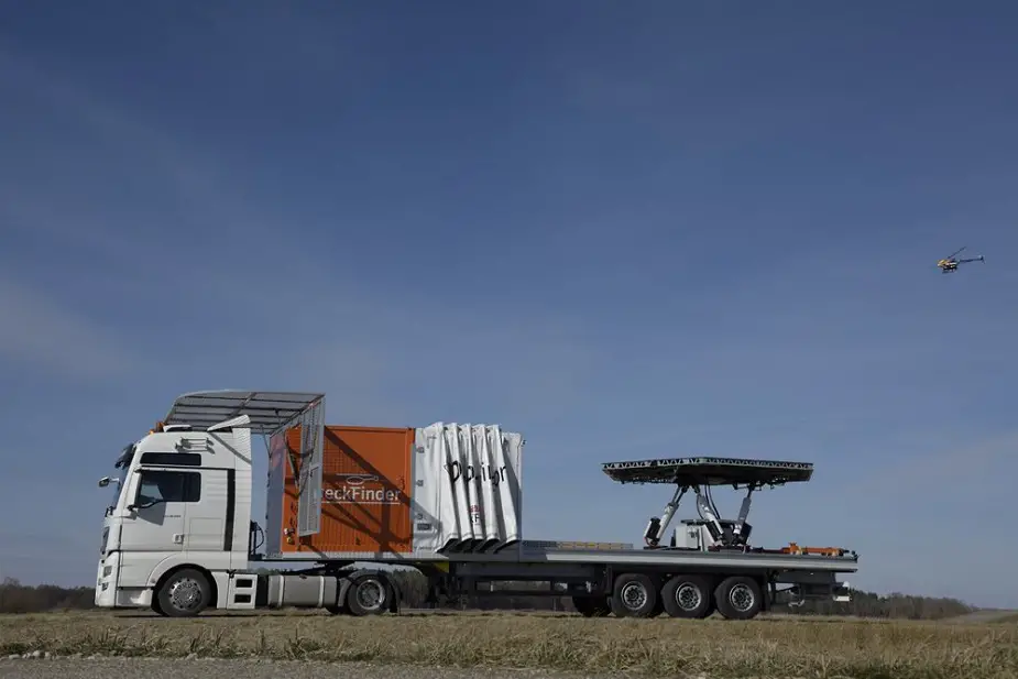 The same principle can be used for landing a RPAS on moving trucks, as during military operations or convoy surveillance missions in areas where GPS may be jammed and vehicles’ safety depends on staying in motion (Picture source: Airbus)
About COMPASS2020:
COMPASS2020 (Coordination Of Maritime assets for Persistent And Systematic Surveillance) aims to demonstrate the combined use and seamless coordination of manned and unmanned assets to achieve greater coverage, better quality of information and shorter response times in maritime surveillance operations. By combining innovative technologies and integrating them within the current operational procedures, COMPASS2020 solution ensures long range and persistent surveillance, increasing the situational awareness of Coast Guards and maritime authorities, thus increasing the cost-effectiveness, availability and reliability of the operations.
The multidisciplinary consortium consists of fourteen partners from nine countries from research, industry and end-users. The COMPASS2020 Project was launched in May 2019 with a duration of 18 months, extended for an additional 6 months due to COVID-19 Impact.